In modern engineering, construction, and environmental projects, precise data is critical for planning, safety, and execution. Utility mapping and Hydrographic and Bathymetric Surveys are essential services that provide accurate and reliable information about underground and underwater infrastructure. These techniques ensure that engineers, architects, and project managers can make informed decisions while reducing risks, costs, and project delays.
Understanding Utility Mapping
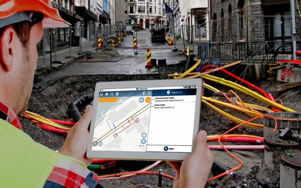
Utility mapping is the process of locating and documenting underground utilities, including water pipes, gas lines, electrical cables, telecommunication networks, and sewer systems. Accurate utility mapping helps prevent accidental damage during excavation or construction projects.
Key benefits of utility mapping include:
- Safety identifying underground utilities reduces the risk of accidents
- Cost Efficiency preventing damage avoids expensive repairs and delays
- Regulatory Compliance adhering to local regulations and construction standards
- Project Planning enables accurate design and execution of infrastructure projects
Modern utility mapping combines advanced technologies such as ground-penetrating radar, electromagnetic induction, and GPS integration to create detailed maps of subsurface assets. These maps provide engineers and contractors with a reliable overview of potential obstacles and existing infrastructure.
Importance of Hydrographic and Bathymetric Surveys
Hydrographic and Bathymetric Surveys are specialized surveying techniques used to measure and map water bodies, including rivers, lakes, coastal areas, and ocean floors. Hydrographic surveys focus on navigational safety and waterway management, while bathymetric surveys measure the underwater topography to determine depths and contours.
Benefits of these surveys include:
- Navigational Safety ensuring safe routes for ships and vessels
- Environmental Monitoring assessing erosion, sedimentation, and water quality
- Infrastructure Planning providing data for bridge, dock, and offshore construction
- Disaster Management aiding flood risk assessment and emergency planning
By using precise survey equipment such as sonar, echo sounders, and GPS-enabled vessels, hydrographic and bathymetric surveys provide accurate data that support both commercial and environmental applications.
Applications of Utility Mapping
Utility mapping plays a critical role across multiple industries, including construction, urban planning, and civil engineering. Common applications include:
- Construction Projects identifying underground utilities before excavation
- Road and Railway Development avoiding conflicts with existing infrastructure
- Urban Planning ensuring proper placement of new pipelines, cables, and services
- Maintenance and Upgrades planning efficient repairs and infrastructure expansion
- Disaster Prevention reducing the risk of accidental utility damage
With detailed utility maps, engineers and contractors can minimize downtime, maintain safety standards, and optimize resource allocation.
Looking for electrical panel manufacturer ? We’re Here to Help!
Applications of Hydrographic and Bathymetric Surveys
Hydrographic and bathymetric surveys are crucial for water-related engineering and environmental projects. Key applications include:
- Port and Harbor Construction ensuring safe navigation and docking
- Dredging Projects determining sediment removal requirements
- Coastal Management monitoring erosion, sediment transport, and sea level changes
- Offshore Structures planning pipelines, oil platforms, and renewable energy installations
- Environmental Studies supporting aquatic habitat protection and water quality monitoring
These surveys provide essential information that enables engineers, environmentalists, and government agencies to make informed decisions while managing risks and costs.
Take the Cricket Quiz & Try Our Free Flip a Coin
Technologies Used in Utility Mapping and Hydrographic Surveys
Modern utility mapping and hydrographic surveys rely on advanced technologies to improve accuracy and efficiency.
For utility mapping, common tools include:
- Ground-Penetrating Radar (GPR) for detecting subsurface structures
- Electromagnetic Induction (EMI) for locating metal pipes and cables
- Global Positioning System (GPS) for accurate georeferencing
- 3D Modeling Software for visualizing underground networks
For hydrographic and bathymetric surveys, equipment typically includes:
- Multibeam and Single Beam Echo Sounders for underwater depth measurement
- Side Scan Sonar for seabed imaging
- GPS and GIS Integration for mapping coordinates and contours
- Autonomous Survey Vessels for efficient data collection in challenging areas
By combining these technologies, surveyors can produce detailed maps, charts, and reports that enhance project planning and safety.
Benefits of Combining Both Services
For comprehensive infrastructure and waterway management, combining utility mapping with hydrographic and bathymetric surveys offers a holistic solution. This integrated approach allows project managers to:
- Identify potential risks both underground and underwater
- Plan construction and excavation with confidence
- Avoid accidental damage to utilities or natural habitats
- Optimize design and routing for pipelines, cables, and waterways
- Improve regulatory compliance and environmental stewardship
By leveraging the strengths of both services, engineers and developers can reduce costs, enhance safety, and improve project efficiency.
Choosing the Right Service Provider
Selecting an experienced and professional service provider is critical for achieving accurate and reliable results. A competent provider should offer:
- Certified Surveyors with expertise in geospatial and hydrographic data
- Advanced Technology using state-of-the-art equipment for precision
- Customized Solutions tailored to the project’s specific needs
- Comprehensive Reporting clear and detailed maps, charts, and recommendations
- Safety and Compliance adherence to industry standards and regulations
Partnering with a reliable service provider ensures that projects are executed smoothly, safely, and within budget.
Future of Utility Mapping and Hydrographic Surveys
As technology evolves, the future of utility mapping and hydrographic surveys is becoming increasingly sophisticated. Trends include:
- Drone-Based Surveys for rapid aerial mapping of large areas
- Automated Data Processing using artificial intelligence and machine learning
- Integration with Building Information Modeling (BIM) for better project planning
- Remote Monitoring for continuous infrastructure and waterway assessment
- Sustainable Practices reducing environmental impact while collecting data
These innovations make surveys faster, more accurate, and more cost-effective while expanding their applications across engineering, environmental, and urban development projects.
Conclusion
Accurate data is the foundation of successful engineering, construction, and environmental management. Utility mapping and Hydrographic and Bathymetric Surveys provide essential information for both underground and underwater infrastructure, helping project managers, engineers, and planners make informed decisions.
By leveraging advanced technology, skilled surveyors, and comprehensive methodologies, these services reduce risks, improve safety, and optimize resources. Integrating utility mapping with hydrographic and bathymetric surveys ensures that projects in urban development, coastal management, and construction are executed efficiently and responsibly.
Whether it is preventing accidental utility damage, planning offshore infrastructure, or monitoring waterways, these services are critical for modern engineering and environmental management. Accurate, reliable, and timely survey data empower decision-makers to execute projects with confidence and precision.
For anyone involved in construction, infrastructure, or waterway management, investing in professional utility mapping and hydrographic and bathymetric surveys is essential for achieving safe, efficient, and successful outcomes.